April 23, 2014
SMART researchers partner with Twitter to decipher big data
A University of Wollongong research team harnessing the power of social media to map floods in the Indonesian capital city Jakarta has been chosen to take part in a pilot project that aims to give researchers free and easy access to Twitter’s dataset.
About 1,300 proposals were submitted by research groups from more than 60 different countries following Twitter’s initial call for proposals for the Twitter #DataGrant project in February 2014. The influential microblogging service has now announced that UOW, along with five other research institutions, including the University of East London and a consortium comprised of Harvard Medical School and Boston Children’s Hospital, was successful.
Dr Tomas Holderness, a Geomatics Research Fellow at UOW’s SMART Infrastructure Facility and one half of the main investigative team behind the selected project, says the Twitter #DataGrant will be a huge benefit for the team’s research.
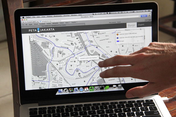
“Our project, PetaJakarta is a web-based platform used to harness the power of social media to gather, sort, and display information about flooding in real time. With access to Twitter’s substantial data set, we will be able to conduct a more comprehensive study.”
PetaJakarta runs on the open source software CogniCity, a “GeoSocial Intelligence framework” developed at the SMART Infrastructure Facility. The software allows data to be collected and disseminated by community members through their location-enabled mobile devices. Ultimately, the team is aiming to use social media data to increase their capacity to understand the resilience of cities to both extreme weather events and long-term infrastructure transformation.
Social media is becoming an integral feature of daily communications, even in the poverty-affected parts of the world. And thanks to geotagging, an individual’s social media message or tweet can be tied to a specific location on the Earth’s surface. The data bank formed with information derived from the content of a tweet and the location from which it was sent is what Dr Holderness and Dr Etienne Turpin, a Vice-Chancellor's Postdoctoral Research Fellow at SMART, are aiming to make sense of and put to good use.
“Social media is ubiquitous, hence geosocial’s power. One of the most exciting prospects for geosocial media is its widespread adoption by the urban poor in many developing nations. Geosocial media has the potential to give unrestricted insight into the lives of million of the poorest people on the planet,” Dr Holderness said, adding that the project is also addressing a UOW Global Challenge as part of the 'Sustaining Coastal and Marine Zones’ research group that is focused on finding solutions to problems posed as a result of the changing climate.
Already, Dr Holderness and Dr Turpin, have used CogniCity to capture tweets sent by Jakarta’s social media savvy residents during the most recent wet season and the resulting information has informed the PetaJakarta pilot study, which will officially run for one year from 1 May, 2014.
Now, with access to Twitter’s historical data, the team will be able to examine tweets sent during past floods, allowing them to paint an even more detailed picture of the situation on the ground.
“We are working with Twitter and the data provider Gnip and hope to access the data in the next few weeks.”
Dr Holderness and Dr Turpin hope that CogniCity will be adopted in other parts of the world with a high concentration of social media users by governments and citizen-led groups wanting to understand and address issues such as transport and traffic congestion, weather emergencies, waste or sewage removal, elections and governance.