October 28, 2014
Citizens’ tweets help researchers map flooding in Jakarta
A big data project mapping instances of flooding in Southeast Asia’s most populous city was launched in Wollongong, Australia, on 29 October 2014.
Using a geosocial intelligence framework developed at the University of Wollongong’s SMART Infrastructure Facility, lead researchers Dr Etienne Turpin and Dr Tomas Holderness are turning geotagged tweets into valuable data that can be analysed and used to map seasonal flooding across the city of Jakarta, Indonesia, with unprecedented detail.
“Jakarta has the fastest rate of urbanisation of any city in the world and a population of about 28 million. River and coastal inundation, sea level rise and recent trends in weather intensification make Jakarta a key site for testing the effectiveness of crowdsourcing data to research 21st century challenges against urban resilience and adaptation,” Dr Holderness said.
“Our research is further supported by the fact Indonesia has the greatest number of Twitter users of any country in the world,” he added.
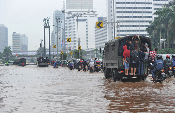
The main street of Jakarta flooded on 18 February, 2013. AFP Photo / Adek Berry
The PetaJakarta (MapJakarta) pilot study, which commenced in May 2014, is being conducted in conjunction with the Jakarta Disaster Management Agency (BPBD, DKI Jakarta). Incessant rain from November through January traditionally culminates with major floods across the CBD and outer city regions. According to BPBD DKI Jakarta, in January 2013, more than one million people were affected by flooding and 80,000 individuals were displaced. In January 2014, more than 16,000 people were affected by flood waters and more than 7,000 were displaced.
As the next monsoon season fast approaches, representatives of BPBD, DKI Jakarta have travelled to Wollongong for the project's official launch and their first week of collaborative training and development to help ensure the success of the project.
“By partnering with BPBD, DKI Jakarta for the one-year pilot study we’ve allowed the agency to work directly with SMART engineers and geographic information system experts to develop tools specifically designed to meet the needs of their day-to-day operations,” Dr Turpin said.
“The overall aim of the project is to advance our capacity to understand and promote the resilience of cities to both extreme weather events as a result of climate change and to long-term infrastructure transformation as a process of climate adaptation,” he added.
Dr Turpin and Dr Holderness expect their product to be widely adopted in the future.
''As an open source publicly accessible platform, the software that runs PetaJakarta can be amended to address other urgent issues such as waste or sewage removal, transport and traffic congestion, weather emergencies, even elections and governance and then re-deployed in other metropolitan areas with high concentrations of social media users,” Dr Turpin said.
PetaJakarta is a key UOW Global Challenges project helping to address the challenge of Sustaining Coastal and Marine Zones and is further supported by Australian National Data Service. The project has also benefited from a Twitter #DataGrant, which was awarded to the lead researchers in April 2014.
Media contact: Jacqueline Wales, UOW Media and PR Officer, +61 2 4221 4582, +61 427 225 657 or jwales@uow.edu.au
This article was updated on 10 November 2014. A previous version stated that in January 2013, 250,000 people were affected by flood waters and in January 2014, 30,000 were displaced.